Geospatial / GIS
Thousands of organisations in virtually every field are using GIS to make data maps that communicate, perform analysis, share information, and solve complex problems around the world. This is changing the way the world works.

Analysis of spatial data
GIS (Geographic Information Systems) analyst’s work involves data analysis, programming and cartography. Their primary duties include the analysis of spatial data through mapping software and generating digital maps with geographic data, photogrammetry and various other data sets.
Analysts need to:
- Identify problems
- Monitor change
- Predict and forecast
- Understand trends
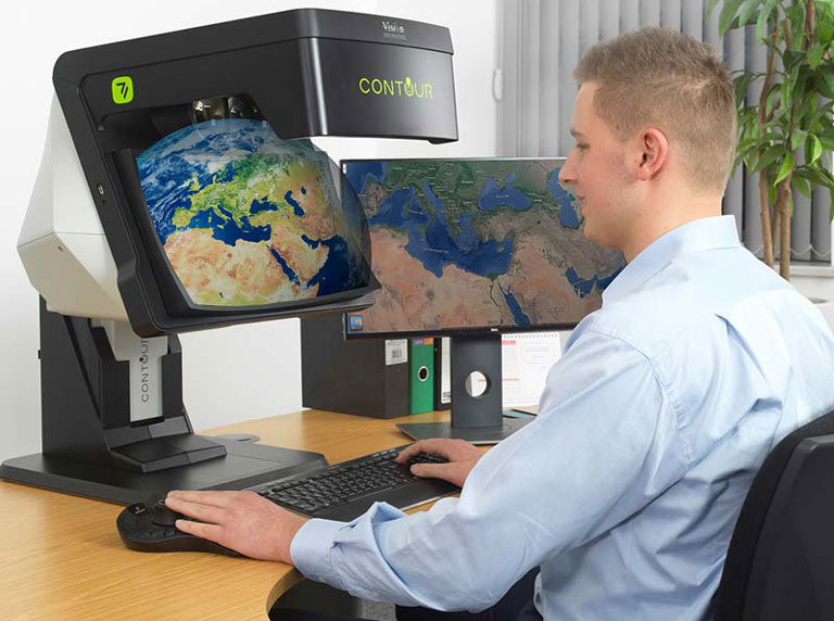
Stereo photogrammetry is at the core of GIS workflows for which stereo display hardware is necessary. Building on 60 years of optical expertise, Vision Engineering offer a range of ergonomic stereo displays which not only provide high image quality, but also help to minimise stress and fatigue for the user.
Geospatial/ GIS Stereo Displays
Stereo analysts require high brightness, flicker-free images with edge to edge image sharpness.
Vision Engineering’s range of ergonomic stereo displays, the CONTOUR and VECTOUR series, fulfil these requirements and help improve confidence of measurements and analysis while maintaining user comfort and productivity.
Application examples
- Photogrammetry
- Mapping analysis
- GIS data interpretation
- Geospatial intelligence
- Utility /Telecom asset management
- Military situational awareness and planning
- Meteorological interpretation
- Oil and gas exploration
- Life science sample development
- Urban planning visualisation applications

CONTOUR
CONTOUR next generation display delivers a unique high quality combination of image clarity, brightness, consistency, ease of use, and operator comfort. CONTOUR’S 3D full high definition (3D FHD) image provides crisp stereo imagery in a unique, glasses-free, system that ensures the image is delivered precisely, consistently, and accurately, with no flickering, ghosting, or cross-talk.

")
DELTOUR
DELTOUR delivers a powerful new way of viewing geospatial imagery. Using advanced lenticular display technology with integrated eye tracking, it presents crisp stereoscopic images directly to your eyes. No special glasses required. Currently available in 15.6″ and 27″ flat-panel displays, with additional screen sizes planned as the range develops, it offers flexible options for a wide variety of geospatial work environments.